Use code RJTJFG for 20% off at checkout. Until 5/31/20

Boundary: Bleed area may not be visible.

The watermark at the lower right corner of the image will not appear on the final product.

by U.S. Geological Survey
$15.00
Size
Image Size
Product Details
Our spiral notebooks are 6" x 8" in size and include 120 pages which are lined on both sides. The artwork is printed on the front cover which is made of thick paper stock, and the back cover is medium gray in color. The inside of the back cover includes a pocket for storing extra paper and pens.
Design Details
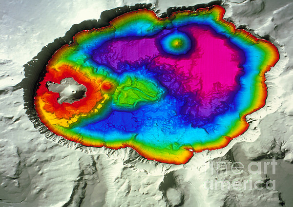
Crater Lake. Colored three-dimensional shaded-relief water depth map of Crater Lake, Oregon, which lies in a volcanic crater, or caldera. The map was... more
Ships Within
2 - 3 business days

Photograph

Canvas Print

Framed Print

Art Print

Poster

Metal Print

Acrylic Print

Wood Print

Greeting Card

iPhone Case

Throw Pillow

Duvet Cover

Shower Curtain

Tote Bag

Round Beach Towel

Zip Pouch

Beach Towel

Weekender Tote Bag

Portable Battery Charger

Bath Towel

Apparel

Coffee Mug

Spiral Notebook

Fleece Blanket

Tapestry

Jigsaw Puzzle

Sticker
Crater Lake. Colored three-dimensional shaded-relief water depth map of Crater Lake, Oregon, which lies in a volcanic crater, or caldera. The map was created from over 50 million sonar depth readings. At 608 meters, this is the deepest US lake. North is at top. Land is grey, with water depth color-coded from pink (deepest), through blue, green and yellow to red (shallowest). Three volcanic cones are seen Wizard Island (grey, center left), Rhyodacite Dome (red, center left) and Merriam Cone (upper right). The caldera formed when the volcano Mount Mazama blew itself apart 7700 years ago. The lake water comes from rain and snow rather than rivers. Data collected from July 2000.
$15.00


There are no comments for Crater Lake #1. Click here to post the first comment.