Use code RJTJFG for 20% off at checkout. Until 5/31/20

Boundary: Bleed area may not be visible.

The watermark at the lower right corner of the image will not appear on the final product.

by Science Source
$17.00
This product is currently out of stock.
Style
Size
Image Size
Product Details
The Center for Disease Control has recommended the use of cloth face masks to help fight the spread of COVID-19.
This face mask is made from 100% polyester and includes two ear loops with adjustable grommets for a comfortable fit.
The printed area of the mask is approximately 7" wide by 5" tall. This mask fits well on adult mens' faces without the grommets but, due to the adjustable grommets, can be worn snuggly by adult women, as well.
Please note - this is NOT a surgical grade mask. It is not intended for any medical or commercial uses, whatsoever. It is a simple, cloth mask designed for everyday use to cover your mouth when out in public. The mask should not be used in any medical or surgical setting.
We make no warranties that the mask prevents infections or the transmission of viruses or diseases.
Design Details
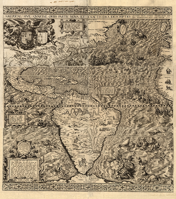
Spanish America. Map of America produced by the Spanish cartographer Diego Gutierrez in 1562. Only two copies of this map are known to exist, one in... more
Ships Within
2 - 3 Business Days

Photograph

Canvas Print

Framed Print

Art Print

Poster

Metal Print

Acrylic Print

Wood Print

Greeting Card

iPhone Case

Throw Pillow

Duvet Cover

Shower Curtain

Tote Bag

Round Beach Towel

Zip Pouch

Beach Towel

Weekender Tote Bag

Portable Battery Charger

Bath Towel

Apparel

Coffee Mug

Yoga Mat

Spiral Notebook

Fleece Blanket

Tapestry

Jigsaw Puzzle

Sticker
Spanish America. Map of America produced by the Spanish cartographer Diego Gutierrez in 1562. Only two copies of this map are known to exist, one in the US Library of Congress, and one in the British Library. Numerous illustrations show land and sea animals, ships, South American natives, a Mexican volcano, South American rivers (Amazon and Parana) and mountain ranges. The map shows Spanish domains following a 1559 treaty between Spain and France (their coats of arms are both at top left, Spain at left; Portugal's is at lower right). Next to France's coat of arms is a note that says Americus Vespucius discovered America in 1497. The map was engraved by the Flemish artist Hieronymous Cock.
$17.00


There are no comments for Spanish America, 16th Century Map. Click here to post the first comment.