Use code RJTJFG for 20% off at checkout. Until 5/31/20


by Science Source
$38.00
Design Location
Color
Image Size
Product Details
Our Bella / Canvas t-shirts are made from a 50% cotton / 50% polyester blend and are available in five different sizes. They're stylish, soft, and incredibly comfortable. Machine wash with cold water, and tumble dry on low heat.
Design Details
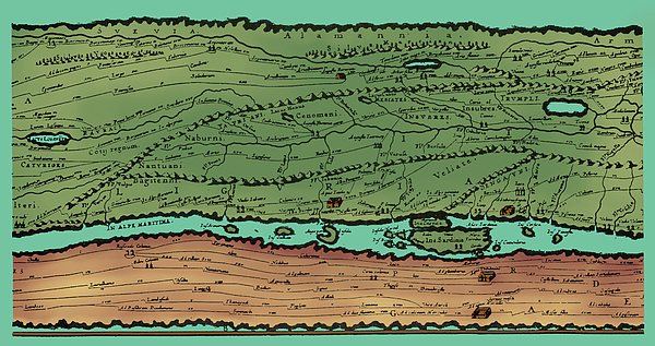
Detail of the Tabula Peutingeriana, an illustrated itinerarium (road map) showing the cursus publicus, the road network in the Roman Empire. The... more
Ships Within
1 - 2 business days

Photograph

Canvas Print

Framed Print

Art Print

Poster

Metal Print

Acrylic Print

Wood Print

Greeting Card

iPhone Case

Throw Pillow

Duvet Cover

Shower Curtain

Tote Bag

Round Beach Towel

Zip Pouch

Beach Towel

Weekender Tote Bag

Portable Battery Charger

Bath Towel

Apparel

Coffee Mug

Yoga Mat

Spiral Notebook

Fleece Blanket

Tapestry

Jigsaw Puzzle

Sticker
Detail of the Tabula Peutingeriana, an illustrated itinerarium (road map) showing the cursus publicus, the road network in the Roman Empire. The original map upon which it is based probably dates to the 4th or 5th century and was itself based on a map prepared by Agrippa during the reign of the emperor Augustus (27 BC - 14 AD) prepared under the direction of Marcus Vipsanius Agrippa, a friend of Augustus. After Agrippa's death, the map was engraved on marble and placed in the Porticus Vipsaniae, not far from the Ara Pacis.
$38.00


There are no comments for Tabula Peutingeriana, Roman Empire Road. Click here to post the first comment.