Use code RJTJFG for 20% off at checkout. Until 5/31/20

Boundary: Bleed area may not be visible.

The watermark at the lower right corner of the image will not appear on the final product.

by Science Source
$3.50
Size
Background Color
Image Size
Background Color
Product Details
Accessorize your life with unique stickers from an independent artist! Our vinyl stickers are available in four different sizes and are kiss-cut to create a 1/8" border around the perimeter of the design. Each sticker has an adhesive backing with plenty of stickiness to cling to any smooth surface while still being easy to remove.
Design Details
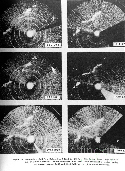
Approach of a cold front as observed on an X-Band radar set at Boston in July, 1943. This is perhaps the oldest preserved image of meteorological... more
Care Instructions
Stickers should be applied to clean, smooth surfaces at room temperature.
Ships Within
2 - 3 business days

Photograph

Canvas Print

Framed Print

Art Print

Poster

Metal Print

Acrylic Print

Wood Print

Greeting Card

iPhone Case

Throw Pillow

Duvet Cover

Shower Curtain

Tote Bag

Round Beach Towel

Zip Pouch

Beach Towel

Weekender Tote Bag

Portable Battery Charger

Bath Towel

Apparel

Coffee Mug

Spiral Notebook

Fleece Blanket

Tapestry

Jigsaw Puzzle

Sticker
Approach of a cold front as observed on an X-Band radar set at Boston in July, 1943. This is perhaps the oldest preserved image of meteorological phenomena as observed by radar. A cold front is the forward edge of an advancing mass of cold air that pushes under a mass of warm air. Cold fronts often cause precipitation; water vapor in the rising warm air condenses and forms clouds, often resulting in heavy rain, thunderstorms, hail, or snow. Winter cold fronts can cause temperatures to drop significantly. Summer cold fronts reduce humidity as drier, cooler air displaces the humid, warmer air. On a weather map, a cold front is depicted as a blue line with triangles that point in the direction in which the cold air is moving.
$3.50


There are no comments for Cold Front, X-band Radar, 1943. Click here to post the first comment.