Use code RJTJFG for 20% off at checkout. Until 5/31/20

Boundary: Bleed area may not be visible.

The watermark at the lower right corner of the image will not appear on the final product.

by Science Source
$70.00
Size
Orientation
Image Size
Product Details
Our premium yoga mats are 24" wide x 72" tall x 0.25" thick and made from natural rubber with a blended microfiber top surface. The top of the mat has the image printed on it, and the back is solid black with textured dimples for better floor grip.
Design Details
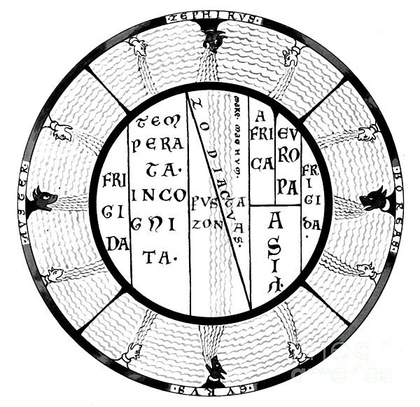
Macrobius T and O map of the Medieval world with the climatic zones and the Mare Magnum, the Great Ocean which was thought to separate the inhabited... more
Care Instructions
Wash with a damp cloth and air dry.
Ships Within
2 - 3 business days

Photograph

Canvas Print

Framed Print

Art Print

Poster

Metal Print

Acrylic Print

Wood Print

Greeting Card

iPhone Case

Throw Pillow

Duvet Cover

Shower Curtain

Tote Bag

Round Beach Towel

Zip Pouch

Beach Towel

Weekender Tote Bag

Portable Battery Charger

Bath Towel

Apparel

Coffee Mug

Yoga Mat

Spiral Notebook

Fleece Blanket

Tapestry

Jigsaw Puzzle

Sticker
Macrobius T and O map of the Medieval world with the climatic zones and the Mare Magnum, the Great Ocean which was thought to separate the inhabited seanworld from an unknown continent in the south. Macrobius Ambrosius Theodosius was a Roman who flourished during the early fifth century. His Commentarii in Somnium Scipionis (Commentary on the Dream of Scipio) allowed him to discourse upon the nature of the cosmos, transmitting much classical philosophy to the later Middle Ages. The T and O map is representing only the top-half of the spherical Earth. It was a projection of the inhabited parts, the northern temperate half of the globe. Since the southern temperate clime was considered uninhabited, there was no need to depict them on a world map. It was then believed that no one could cross the torrid equatorial clime and reach the unknown lands on the other half of the globe. These imagined lands were called antipodes. The T is the Mediterranean, the Nile, and the Don (formerly called t...
$70.00


There are no comments for Macrobius T And O Medieval World Map. Click here to post the first comment.