Use code RJTJFG for 20% off at checkout. Until 5/31/20

Boundary: Bleed area may not be visible.

The watermark at the lower right corner of the image will not appear on the final product.

by Photo Researchers
$40.00
Size
Orientation
Image Size
Product Details
Decorate your bathroom and dry yourself off with our luxuriously soft bath towels and hand towels. Our towels are made from brushed microfiber with a 100% cotton back for extra absorption. The top of the towel has the image printed on it, and the back is white cotton. Available in three different sizes: hand towel, bath towel, and bath sheet.
Design Details
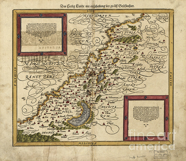
16th century map of Palestine. North is towards upper right. Published in 1588, this German map shows the geography of Palestine, centerd on the area... more
Care Instructions
Machine wash cold and tumble dry with low heat.
Ships Within
1 - 2 business days

Photograph

Canvas Print

Framed Print

Art Print

Poster

Metal Print

Acrylic Print

Wood Print

Greeting Card

iPhone Case

Throw Pillow

Duvet Cover

Shower Curtain

Tote Bag

Round Beach Towel

Zip Pouch

Beach Towel

Weekender Tote Bag

Portable Battery Charger

Bath Towel

Apparel

Coffee Mug

Yoga Mat

Spiral Notebook

Fleece Blanket

Tapestry

Jigsaw Puzzle

Sticker
16th century map of Palestine. North is towards upper right. Published in 1588, this German map shows the geography of Palestine, centerd on the area that later become the state of Israel. The inscriptions are in German, and the place names are in Latin. These include ancient names like Petra, Coele Syria and Judea. The Dead Sea is at lower center, and the Mediterranean coast is at left. Numerous towns and villages are shown on the map. The map is by the German cartographer Sebastian Munster (1489-1552), and was published in Basel in a posthumous edition of his Cosmographia, the earliest German atlas.
$40.00


There are no comments for Map Of Palestine, 1588. Click here to post the first comment.