Use code RJTJFG for 20% off at checkout. Until 5/31/20

Boundary: Bleed area may not be visible.

The watermark at the lower right corner of the image will not appear on the final product.
Inside Message (Optional)
Inside View

by Photo Researchers
$6.95
Quantity
The more you buy... the more you save.
Orientation
Image Size
Product Details
Our greeting cards are 5" x 7" in size and are produced on digital offset printers using 100 lb. paper stock. Each card is coated with a UV protectant on the outside surface which produces a semi-gloss finish. The inside of each card has a matte white finish and can be customized with your own message up to 500 characters in length. Each card comes with a white envelope for mailing or gift giving.
Design Details
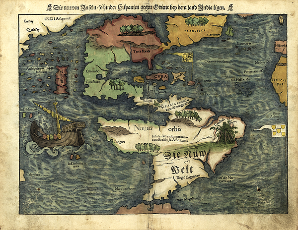
16th century map of the Americas. Published in 1550, this German map shows a rudimentary geography of the newly-discovered Americas. The inscriptions... more
Ships Within
2 - 3 business days

Photograph

Canvas Print

Framed Print

Art Print

Poster

Metal Print

Acrylic Print

Wood Print

Greeting Card

iPhone Case

Throw Pillow

Duvet Cover

Shower Curtain

Tote Bag

Round Beach Towel

Zip Pouch

Beach Towel

Weekender Tote Bag

Portable Battery Charger

Bath Towel

Apparel

Coffee Mug

Yoga Mat

Spiral Notebook

Fleece Blanket

Tapestry

Jigsaw Puzzle

Sticker
16th century map of the Americas. Published in 1550, this German map shows a rudimentary geography of the newly-discovered Americas. The inscriptions on South America are in German; the other place names are in Latin. Areas explored by the Spanish from the 1490s onwards included Cuba and Florida, as well as Central and South America. The area further north, in North America, was explored by the French in the 1520s and 1530s. To the west, Japan (known to Europeans from 1542) and India are incorrectly shown next to North America. This map, by the German cartographer Sebastian Munster (1489-1552), was published in Basel in an edition of his Cosmographia, the earliest German atlas.
$6.95


There are no comments for Map Of The Americas 1550. Click here to post the first comment.