Use code RJTJFG for 20% off at checkout. Until 5/31/20

Boundary: Bleed area may not be visible.

The watermark at the lower right corner of the image will not appear on the final product.

by Photo Researchers
$3.50
Size
Background Color
Image Size
Background Color
Product Details
Accessorize your life with unique stickers from an independent artist! Our vinyl stickers are available in four different sizes and are kiss-cut to create a 1/8" border around the perimeter of the design. Each sticker has an adhesive backing with plenty of stickiness to cling to any smooth surface while still being easy to remove.
Design Details
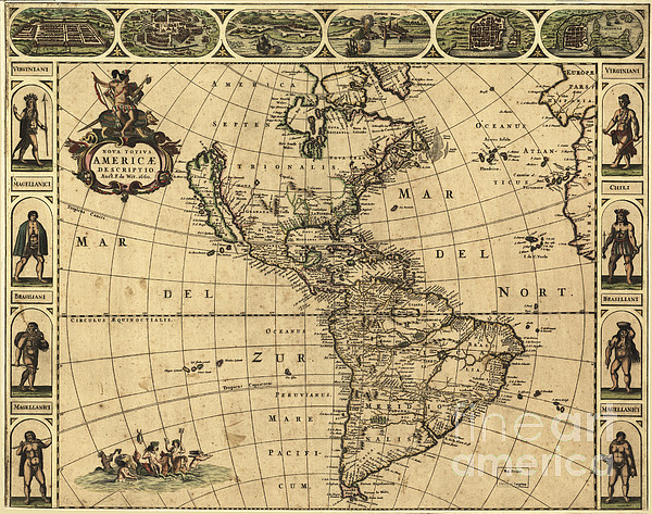
17th century map of the Americas. Published in Amsterdam in 1660, this map by the Dutch cartographer Frederick de Wit (c.1630-1706) shows the... more
Care Instructions
Stickers should be applied to clean, smooth surfaces at room temperature.
Ships Within
2 - 3 business days

Photograph

Canvas Print

Framed Print

Art Print

Poster

Metal Print

Acrylic Print

Wood Print

Greeting Card

iPhone Case

Throw Pillow

Duvet Cover

Shower Curtain

Tote Bag

Round Beach Towel

Zip Pouch

Beach Towel

Weekender Tote Bag

Portable Battery Charger

Bath Towel

Apparel

Coffee Mug

Yoga Mat

Spiral Notebook

Fleece Blanket

Tapestry

Jigsaw Puzzle

Sticker
17th century map of the Americas. Published in Amsterdam in 1660, this map by the Dutch cartographer Frederick de Wit (c.1630-1706) shows the geography of the Americas, the New World being explored by Europeans. The exploration of South America was well advanced by this stage, but large swathes of North America had yet to be mapped. The artworks across top show various cities, from left to right Cusco (Peru); Tenochtitlan (labeled Mexico, now Mexico City); Olinda (Brazil); Havana (Cuba); San Domingo (Hispaniola); and Cartagena (Colombia). The artworks at left and right show natives of Virginia (north-eastern North America), Chile and Brazil, and the 'Magellanic' people of Patagonia.
$3.50


There are no comments for Map Of The Americas, 1660. Click here to post the first comment.