Use code RJTJFG for 20% off at checkout. Until 5/31/20

Boundary: Bleed area may not be visible.

The watermark at the lower right corner of the image will not appear on the final product.
Inside Message (Optional)
Inside View

by Los Alamos National Laboratory
$6.95
Quantity
The more you buy... the more you save.
Orientation
Image Size
Product Details
Our greeting cards are 5" x 7" in size and are produced on digital offset printers using 100 lb. paper stock. Each card is coated with a UV protectant on the outside surface which produces a semi-gloss finish. The inside of each card has a matte white finish and can be customized with your own message up to 500 characters in length. Each card comes with a white envelope for mailing or gift giving.
Design Details
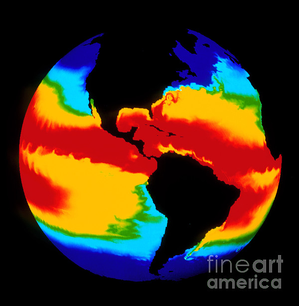
Computer model of global sea surface temperature. Computed sea surface temperatures mapped onto a sphere. The temperatures are color coded from red... more
Ships Within
2 - 3 business days


Canvas Print

Framed Print

Art Print

Poster

Metal Print

Acrylic Print

Wood Print

Greeting Card

iPhone Case

Throw Pillow

Duvet Cover

Shower Curtain

Tote Bag

Round Beach Towel

Zip Pouch

Beach Towel

Weekender Tote Bag

Portable Battery Charger

Bath Towel

Apparel

Coffee Mug

Yoga Mat

Spiral Notebook

Fleece Blanket

Tapestry

Jigsaw Puzzle

Sticker
Computer model of global sea surface temperature. Computed sea surface temperatures mapped onto a sphere. The temperatures are color coded from red (warmest) through green and yellow to blue (coolest). The model has predicted several real-world phenomena, such as the Gulf Stream (upper right) and the Falkland current off South America (lower right). Large eddy streets are seen in equatorial latitudes, and large-scale waves are seen in the tropical Pacific. The model used a spatial resolution of 0.5 degrees of latitude and longitude and 20 vertical depth levels, combined with realistic ocean floor topography.
$6.95


There are no comments for Computer Simulation Of Global Sea. Click here to post the first comment.